
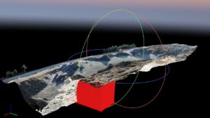
Cautus 3D modeling

Cautus Geo provides 3D modeling and analysis services for areas with high risk of rockslides and landslides, as well as areas such as quarries where removal of rock masses is taking place.
The surveying method used involves usage of drones for aerial photo collection and measurement of fixed points and/or laser scanning for generation of a 3D point cloud. Measurement sets are then used to analyze characteristics such as deformation/movement in rock masses over time, strike and dip orientation and calculation of volume and changes in volume.
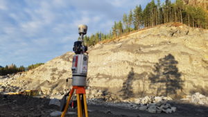
This surveying method is based on new technology and is an accurate, efficient and cost-effective toll compared to tranditional methods.
When combined with laser scanning, picture comparison data can provide an even better foundation for further analysis of an area of interest.
Applications:
- Surveying of movement and deformation, both small and large scale, in landslide-prone areas.
- Surveying of strike and fall in rock layers to determine appropriate safety measures in surface mining operations.
- Measurement of changes in volume over time related to blasting, removal, storage and production.
- Documentation of extraction related to operating permit and control plan.
- 3D presentation of extraction through images and video for use in presentations and marketing.
- Export of 3D models/point clouds for use in illustration and other programs.
Send a request
Tell us about your surveying project! Contact us today via email or phone: